


The Hogenburg map
Back to Time Period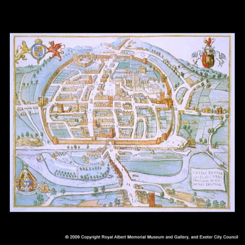
The map (really a bird's eye view) is the earliest contemporary record of the form of Exeter and one of the earliest maps of any English town. It was commissioned by the city in 1584-5 through the services of its Chamberlain, John Hooker, whose coat of arms appears at the bottom left . This engraving was prepared by Remigius Hogenburg and published in the Low Countries in 1618 in the volume Civitates Orbis Terrarum (The Cities of the Lands of the World). Viewed from St Thomas, with Exe Bridge in the foreground and the walled city beyond, the view carefully presents the layout of the streets and the principal buildings. Just how reliable the details of buildings are, especially smaller ones, is more uncertain.
Acknowledgments: RAM Museum

 is the earliest contemporary record of the form of Exeter and one of the earliest maps of any English town. It was commissioned by the city in 1584-5 through the services of its Chamberlain, John Hooker, whose coat of arms appears at the bottom left . This engraving was prepared by Remigius Hogenburg and published in the Low Countries in 1618 in the volume Civitates Orbis Terrarum (The Cities of the Lands of the World). Viewed from St Thomas, with Exe Bridge in the foreground and the walled city beyond, the view carefully presents the layout of the streets and the principal buildings. Just how reliable the details of buildings are, especially smaller ones, is more uncertain.)