


Plan of Exeter in the 11th century
Back to Time Period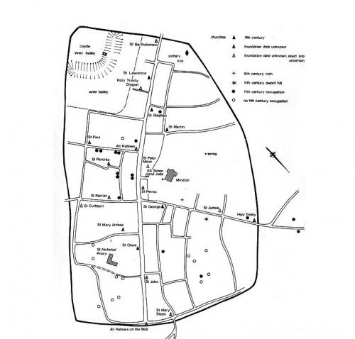
This plan shows the area of the walled city (the heavy line enclosing most of the plan) and the parts of the suburbs just outside the walls. There are many uncertainties about the late Saxon town plan: streets within the city are recorded in documents only in later centuries, but various strands of evidence strongly suggest that their layout belongs essentially to the late Saxon period.
At the centre of the town is the old Anglo-Saxon minster church with its burial ground, around which the street plan was laid out (note the kink in High Street to avoid it). The broad High Street and much narrower side streets are evident. Along the length of the High Street were plots about 120 feet deep, behind which ran narrow lanes.
Intensive Late Saxon (10th and early 11th century) occupation was found in excavation of city centre sites in the area around St Pancras church. The plan shows the sites where such occupation is evident (black dots), with sites around the edges of the walled area which seem to have been empty at this date.
Source: Haslam, J. (ed.) 1984 'Anglo-Saxon Towns in Southern England'.
Acknowledgments: Source: Haslam, J. (ed.) 1984 'Anglo-Saxon Towns in Southern England'.

 and the parts of the suburbs just outside the walls. There are many uncertainties about the late Saxon town plan: streets within the city are recorded in documents only in later centuries, but various strands of evidence strongly suggest that their layout belongs essentially to the late Saxon period.
At the centre of the town is the old Anglo-Saxon minster church with its burial ground, around which the street plan was laid out (note the kink in High Street to avoid it). The broad High Street and much narrower side streets are evident. Along the length of the High Street were plots about 120 feet deep, behind which ran narrow lanes.
Intensive Late Saxon (10th and early 11th century) occupation was found in excavation of city centre sites in the area around St Pancras church. The plan shows the sites where such occupation is evident (black dots), with sites around the edges of the walled area which seem to have been empty at this date.
Source: Haslam, J. (ed.) 1984 'Anglo-Saxon Towns in Southern England'.)